
Beyond the Dashboard: The Operational Digital Twin in Traffic Management
Published at Verkeerskunde.nl
Many of the mobility applications that we call digital twins are actually digital models or digital shadows. They are great for gaining insight and control, but what operational traffic management needs are digital representations that not only observe and predict, but can also intervene (autonomously or not) using the available DTM tools in the city.
The concept of digital twin is very popular in the world of mobility. All kinds of traffic models, dashboards, 3D environments, real-time viewers and data platforms are being called by that name. It seems to make sense: all these applications translate the physical traffic situation into a digital representation that is easy to analyze. And yet they are not all digital twins.
A dashboard can give a real-time picture of the traffic. A traffic model can be indispensable for analysis and planning. A short-term prediction can help an operator look ahead. But an operational digital twin goes beyond that: it uses current information to interpret the traffic situation, evaluate measures, and manage the operation.
Four Levels of Digital Representation
The digital twin originated in astronautics, where simulators and models were used as far back as the 1960s. The NASA technologist John Vickers and the scientist Michael Grieves came up with the following definition:
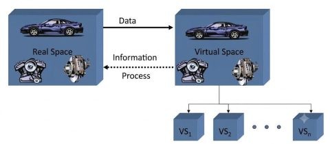
Digital twin: The virtual representation of a physical system, with which it remains connected throughout its life cycle. Constant two-way traffic is crucial: current data from reality feeds the digital model and insights from this model immediately lead to decisions or actions in physical reality.
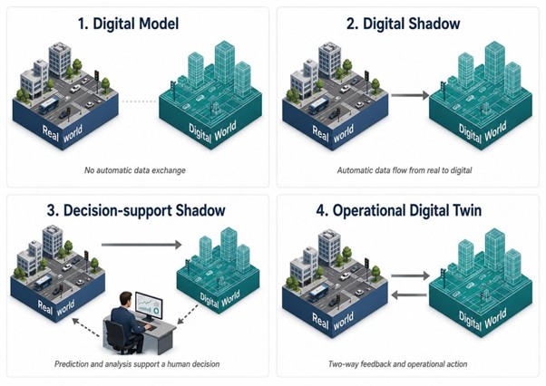
On the basis of this definition, we can distinguish four levels of digital representation:
- Digital model: A digital model has no automatic connection with the current reality. Offline traffic, simulation, or scenario models are examples of digital models.
- Digital shadow: A digital shadow is fed automatically with current data from reality, for example dashboards with detection loop data, TLC data, floating car data, parking data, or bridge openings. Digital shadows give operators a current image of the situation, but do not themselves change reality.
- Decision-support shadow: A decision-support shadow goes one step further: it enriches current data with analysis or a short-term prediction. The operator or traffic engineer can use this information, but the step from prediction to intervention is still manual.
- Operational digital twin: An operational digital twin is fed with current data and then intervenes in reality on the basis of this. It does this for example through scenario selection, automatic operation, or human decision-making. The main difference with a decision-support shadow is that the step from digital insight to physical intervention is integrated into the system.
From traffic picture to DTM chain
An operational digital twin can be seen as that part of a DTM chain that performs the following steps:
- Collecting current data from all available sources (measuring).
- Reconstructing and interpreting the current situation (understanding).
- A model or simulation predicts the immediate future (predicting).
- Calculating and assessing measures or scenarios (assessing).
- Preparing or activating the action through an operator or automatically (intervening).
- Measuring the effect in the physical world and feeding this back (evaluating).
Organizations such as DMI and Geonovum have laid an important foundation for operational digital twins in DTM and managing public space, focusing for example on data, interoperability, standards, governances, and guardrails. In addition, operational traffic management requires operational management logic, with short timeframes and concrete questions:
What decision has to be taken when? What data is reliable enough? What types of interventions are available? Who is authorized to intervene? How do we measure the effect?
Usecase: Closed-Loop Corridor Management (Marysville, Ohio)
In Marysville (Ohio, USA), Technolution has implemented a Traffic Flow Engine (TFE) for multimodal corridor optimization. The system reconstructs the traffic situation in real time, predicts object movements, optimizes phase plans, and feeds this back to the traffic control installation.
Crucial aspects of this application are:
- Measuring: FlowCube sensors at the intersections detect and categorize all road users (for example cars, cyclists, pedestrians).
- Understanding: The TFE translates the data from the FlowCube sensors into a digital representation of these objects on a map of the city.
- Predicting: The system makes short-term predictions about all sensible phase plans.
- Assessing: The TFE assesses every prediction on the basis of multimodal priorities and policy frameworks.
- Intervening: The best prediction determines the next phase plan and is automatically fed back to the traffic light.
The TFE in Marysville shows that an operational digital twin does not have to look like a digital maquette of the city. The system has been operational since 2023 and supports the city 24/7.
Usecase: Multimodal Predictive Traffic System (Groningen)
In Groningen, MobiMaestro collects measurement data from detection loops throughout the city. This data is sent to Goudappel/dat.mobility’s Multimodal Predictive Traffic System, which hosts a macro-dynamic OmniTRANS model. This model is automatically calibrated using new measurement data and feeds back a short-term prediction to the operator.
Crucial aspects of this application are:
- Measuring: Detection loops detect the passage of vehicles at intersections in Groningen.
- Understanding: The Multimodal Predictive Traffic System processes the data from the detection loops and transforms it into input information for the automatic calibration, complemented by current data from MELVIN.
- Predicting: A macro-dynamic traffic model simulates the expected traffic flows for the coming 30 minutes.
- Assessing: The predicted traffic situation is fed back to the operator as a complementary insight in addition to the current situation.
- Intervening: The operator decides what interventions are required. Automatic activation of scenarios is possible too.
The Multimodal Predictive Traffic System illustrates that the development toward operational digital twins is a gradual process. A predictive traffic model that is automatically calibrated on the basis of real-time data is very valuable for the operator when planning and activating scenarios. Even if we cannot currently go all the way to scenario activation and effect measurement without operator supervision.
What Does This Ask from Traffic Engineering in Practice?
These different types of digital representation do not exist on a scale from good to bad. Digital shadows are often needed to make data usable and insightful, and decision-support shadows help operators look ahead.
But if we want to go beyond this to using an operational digital twin, we will have to think about a lot more than just data and visualization. What we need then is data quality, latency, validation, explainability, fallback, operator workflow, mandate, responsibilities, and effect measurement. Every system that recommends or activates a particular intervention will have to explain and record on what data, assumptions, and uncertainties the recommendation or decision is based.
Doing that transforms a digital twin from a technical system into a traffic engineering and organizational tool. This requires making clear choices about a range of things: what public values are we optimizing, what traffic modes have priority, when is a system permitted to act autonomously, when does human supervision remain necessary, and how do we learn from the outcomes?
Operational digital twins cannot replace a traffic engineer or operator. What they can do is make the DTM chain clearer. What are we seeing? What do we expect? What intervention does this require? Who decides? And how do we know whether it worked or not?
The value of an operational digital twin ultimately lies not in a richer digital image of the city, but in optimization of the DTM chain.