Smart Urban Traffic Zones
Instruments for a livable city
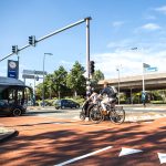
7.13 a.m. Olle Lundqvist sets off from the bakery depot toward downtown Gothenburg to deliver freshly baked fika pastries to Espresso House on Kyrkogatan. This used to be a frustrating ride: a narrow street where offloading goods is difficult. But now Olle uses an app that tells him which loading bays are available. “Saves me endless searching again,” he thinks with satisfaction.
With more than 600,000 inhabitants, Gothenburg is a big city. A huge number of deliveries are made in the historic center on a daily basis. In the context of its Smarta Urbana Trafikzoner (Smart Urban Traffic Zones) project, the city has equipped dozens of delivery vans with a GPS tracker to gain real-time insight into how Gothenburg’s more than 400 loading bays are used. Technolution provided the services to make this possible.
Overview of the occupancy of loading bays is part of curb management. Free sidewalks and curbs are becoming scarce due to the rise of delivery services, shared mobility, and charging stations. But sensors and other sources of data can tell us how curbs are being used. This data forms the basis for digital control, but can also be connected to law enforcement agencies for targeted law enforcement.
Curb management and other applications of Smart Urban Traffic Zones are likely to play a greater role in the future. Smart application and connection of sensors, vehicle information, GPS data, DRIPs, and TLCs will allow cities to establish ever more effective control over the way the road and the public space are used.
Smart measures for livability and accessibility
The technology of Smart Urban Traffic Zones (or smart access) can be used for a variety of purposes, allowing cities to take targeted measures to improve livability and accessibility. To give a few examples:
Environmental zones and emissions control: Smart zones can identify high-emission vehicles and limit their access or impose charges.
Geofencing for security and mobility management: Cities can close off zones to heavy traffic. Only trucks that have temporary permits are allowed in. The permitted route is communicated digitally.
Freight traffic on bus lanes: Bus lanes can be automatically made accessible to freight traffic whenever they are not in use by buses.
Priority for electric vehicles: EVs are given automatic access to specific lanes or parking places in emission-free zones.
The further development of our traffic management platform MobiMaestro will support curb management and other forms of smart access. As the example from Gothenburg shows, even having greater insight is a step forward that can make life easier for delivery drivers such as Olle. A next step could be to give the city greater control, for example by reserving loading bays or implementing dynamic use of them. These and other forms of Smart Urban Traffic Zones are giving cities a handle on the configuration and use of the public space.
Services for smooth loading and unloading
Gothenburg is using these Technolution Move services to provide parcel delivery companies current and historical information about available loading bays in the city.
Determine what loading bays are occupied: This service aggregates GPS tracker data every minute, strips it of privacy-sensitive information, and determines what loading bays are currently occupied.
Real-time insight for drivers: The aggregated data is sent to an app that gives drivers real-time overview of the loading bays in the city.
Historical analysis: The data is fed to a tool for historical analysis. Delivery companies use the historical data to plan their delivery routes.
Camera support: The GPS data only shows vans that participate in the project, but another vehicle or a waste disposal vehicle could also be using a loading bay. This is why some places are equipped with camera-based sensors. Technolution merges this sensor data with the GPS data to give delivery drivers a reliable image.